团队研究方向:
1. 极端自然条件下地理环境信息获取技术
2. 高原系统地震致灾规律和中长期效应
3. 岩石层-大气层-电离层-磁层(LAIM)耦合机制
4. 高原灾害智能监测与智慧减灾
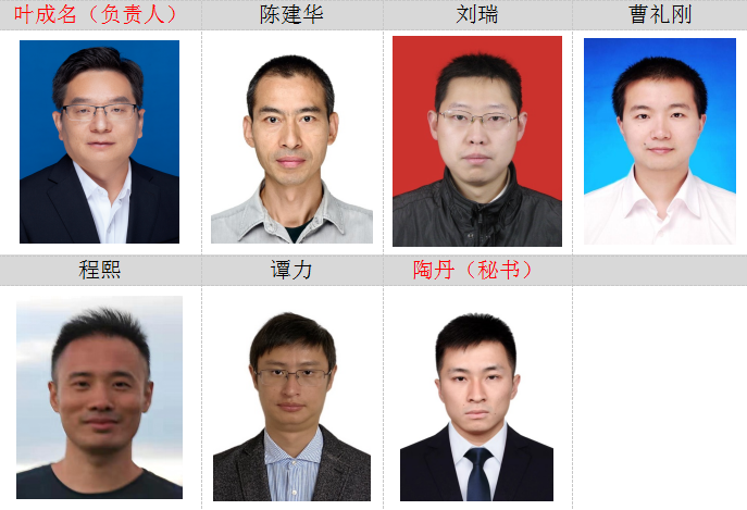
团队成员:
团队主要项目:
项目名称 |
负责人 |
纵向项目类别 |
立项时间 |
立项编号 |
破坏模式约束下基于LiDAR点云数据的滑坡多要素信息智能提取与综合方法 |
叶成名 |
国家自然科学基金 |
2020 |
42071411 |
地震-电离层TEC扰动的极性特征分析及其LAI耦合模型验证 |
陶丹 |
国家自然科学基金 |
2020 |
42004137 |
自动化的多源遥感不透水面信息提取 |
程熙 |
国家自然科学基金 |
2013 |
41301488 |
面向油气储层综合评价的空间案例推理模型与方法 |
陈建华 |
国家自然科学基金 |
2012 |
41101366 |
综合多特征的建筑物震害SAR图像定量化检测研究 |
叶成名 |
国家自然科学基金 |
2010 |
41001253 |
孕灾环境时空信息遥感提取与分析 |
叶成名 |
科技部二次青藏科考子题 |
2019 |
2019QZKK0902 |
典型地质灾害遥感快速提取技术 |
叶成名 |
国家重点研发计划子题 |
2016 |
2016YFB0502603 |
高光谱遥感建筑物灾损信息快速提取方法研究 |
叶成名 |
高分重大专项子题 |
2014 |
03-Y30B06-9001-13/15 |
基于集成监测手段的电离层“地震前兆”特征及机制研究——以华蓥山断裂带(川南)强震为例 |
陶丹 |
四川省科技厅 |
2022 |
2022NSFSC0213 |
LiDAR点云滑坡智能识别方法及系统研发 |
叶成名 |
四川省科技厅 |
2021 |
2022YFG0200 |
地质空间元胞自动机关键技术研究与应用 |
陈建华 |
四川省科技厅 |
2019 |
2019YFG0187 |
面向县域尺度的生态服务功能服务遥感评估方法研究 |
叶成名 |
四川省科技厅 |
2015 |
2015SZ0198 |
基于因子分析法的芦山震后滑坡风险评价模型研究 |
刘瑞 |
四川省科技厅 |
2014 |
14ZB0071 |
团队获奖情况:
1. 青藏高原东缘龙门山活动构造与地震灾害效应研究,四川省科学技术进步奖,一等奖,叶成名,2022年。
2. 多源地质数据智能处理技术及区域矿产资源预测应用,四川省科学技术进步奖,三等奖,陈建华,2022年。
3. 深地探测中的地球地磁勘探方法及应用,四川省科学技术进步奖,一等奖,曹礼刚,2018年。
团队主要研究成果:
1. Wei, R., Ye, C., Ge, Y., Li Y. (2022). An attention constrained neural network with overall cognition for landslide spatial prediction. Landslides, 19(5), 1087-1099, doi:10.1007/s10346-021-01841-z.
2. Wei, R., Ye, C., Sui, T., et al. (2022). Combining spatial response features and machine learning classifiers for landslide susceptibility mapping. International Journal of Applied Earth Observations and Geoinformation, 107, 102681, doi:10.1016/j.jag.2022.102681.
3. Ye, C., Wei, R., Ge, Y., et al. (2022). GIS-based spatial prediction of landslide using road factors and random forest for Sichuan-Tibet Highway. Journal of Mountain Science 19(2). https://doi.org/10.1007/s11629-021-6848-6.
4. Liu, R., Li, G., Wei, L., et al. (2022). Spatial prediction of groundwater potentiality using machine learning methods with Grey Wolf and Sparrow Search Algorithms[J]. Journal of Hydrology: 610(2022)127977. doi: 10.1016/j.jhydrol.2022.127977.
5. Liu, R., Yang, X., Xu, C., et al. (2022). Comparative Study of Convolutional Neural Network and Conventional Machine Learning Methods for Landslide Susceptibility Mapping. Remote Sensing, doi:10.3390/rs14020321.
6. Tao, D., Wang, G., Zong, J., et al. (2022). Are the Significant Ionospheric Anomalies Associated with the 2007 Great Deep-Focus Undersea Jakarta–Java Earthquake? Remote Sensing, 14(9), 2211. https://doi.org/ 10.3390/rs14092211.
7. Li, G., Tan, L., Liu, X., et al. (2022). Feature-Based Convolutional Neural Network for Very-high-resolution Urban Imagery Classification. Photogrammetric Engineering & Remote Sensing, 88(6), 399-405(7). https://doi.org/10.14358/ PERS.21-00055R2.
8. Chen, J., Wang, B., Wang, F., et al. (2021). Identification of outcropping strata from UAV oblique photogrammetric data using a spatial case-based reasoning model. International Journal of Applied Earth Observation and Geoinformation, 103, 102450. https://doi.org/10.1016/j.jag.2021.102450.
9. Cheng, X., Luo, R., Shi, G., et al. (2020). Automated detection of impervious surfaces using night-time light and Landsat images based on an iterative classification framework. Remote Sensing Letters, 11(5), 465–474. https://doi.org/10.1080/2150704X.2020.1730471.
10. Ye, C., Li, Y., Cui, P., et al. (2019). Landslide Detection of Hyperspectral Remote Sensing Data Based on Deep Learning with Constrains. IEEE Journal of Selected Topics in Applied Earth Observations and Remote Sensing, 12(12), 5047-5060, doi: 10.1109/JSTARS.2019.2951725.
团队联系方式:
教师:
叶成名(13980052956,北翼楼5218室)
陶 丹(17358576935,北翼楼5814室)
研究生:
张华俊(17313187750)
王婷婷(15198265215)